
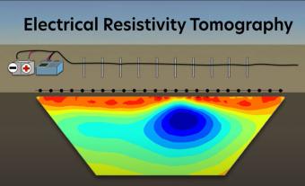
Electrical resistivity tomography (ERT) is a method for learning about the ground below our feet. It can help with finding pumpable groundwater, areas of pollution, hidden caves, and much much more. This animation overviews how ERT surveys work and what they are used for.
TEASER: Intro to IRIS's "Geographic Region" series. Our "World Series" addresses regional tectonic forces and resulting recent and historic earthquakes around the world (ex. Japan, Alaska, Peru-Chile, Central America, Mexico, Pacific Northwest).
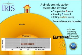
Seismic waves travel through the earth to a single seismic station. Scale and movement of the seismic station are greatly exaggerated to depict the relative motion recorded by the seismogram as P, S, and surface waves arrive.
A gridded sphere is used to show:
1) the seismic stations don't need to be lined up longitudinally to create travel-time curves,
as they appear in the first animation, and
2) a single station records widely separated earthquakes that plot on the travel-time curves.
Earth science is not simple. It frequently deals with difficult concepts, abstractions, mathematical laws, and theory. With this series of animations under 2 minutes, we hope to address common misunderstandings, misconceptions and myths.
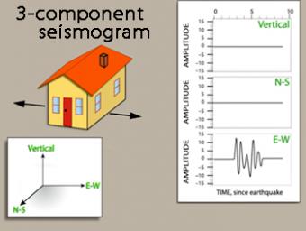
We use exaggerated motion of a building (seismic station) to show how the ground moves during an earthquake, and why it is important to measure seismic waves using 3 components: vertical, N-S, and E-W. Before showing an actual distant earthquake, we break down the three axes of movement to clarify the 3 seismograms.
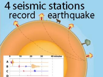
A cow and a tree in this narrated cartoon for fun and to emphasize that seismic waves traveling away from an earthquake occur everywhere, not just at seismic stations A, B, C, and D. A person would feel a large earthquake only at station A near the epicenter. Stations B, C, D, and the cow are too far from the earthquake to feel the seismic waves though sensitive equipment records their arrival.
This companion to the animation "Four-Station Seismograph network" shows the arrival of seismic waves through select wave paths through the Earth (P and S waves) and over the surface of the Earth. The movement at distant stations occurs at a microscopic scale. While that doesn't result in noticeable movements of the buildings, the arrivals are recorded on sensitive seismometers.
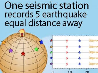
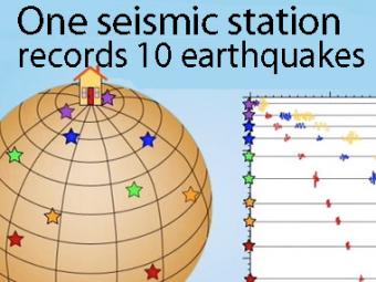
A gridded sphere is used to show a single station recording five equidistant earthquakes.
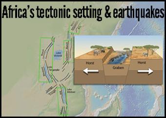
The African Plate is a major tectonic plate that includes much of the continent of Africa, as well as oceanic crust which lies between the continent and surrounding ocean ridges.
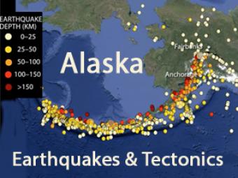
Alaskan tectonics are dominated by the Pacific-North American plates. The megathrust boundary between the plates results in both the 4,000-km-long Aleutian Trench and in the arc of active volcanoes that lie subparallel to the trench.
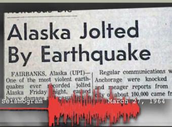
The 1964 Great Alaska Earthquake occurred on Good Friday, March 27th. Liquefaction in and around Anchorage tore the land apart. At magnitude 9.2, it was the second largest quake ever recorded by seismometers.
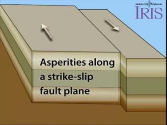
An asperity is an area on a fault that is stuck or locked. Scientists study areas along long fault zones that have not had earthquakes in a long time in order to determine where the next earthquake may occur. As long faults move, all areas of it will, at some point, become "unstuck" causing an earthquake relative to the the size of the asperity that finally breaks.
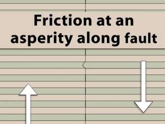
View looking into a fault zone with a single asperity. Regional right lateral strain puts stress on the fault zone. A single asperity resists movement of the green line which deforms before finally rupturing.
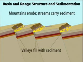
As extension and uplift occur, erosion and sedimentation happen simultaneously but at slower rates. As extension slows down, erosion and sedimentation can overcome mountain building.
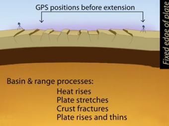
Simplified extension of the basin and range province as reflected in the GPS (global positioning system) stations at distant ends of the region. Tension created by movements of Earth's tectonic plates have stretched the earth's surface to the breaking point. The entire region has been pulled apart, fracturing the tectonic plates and creating large faults.
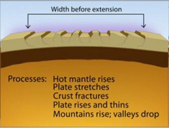
Over most of the last 30 million years, movement of hot mantle beneath the region caused the surface to dome up and then partially collapse under its own weight, as it pulled apart. Currently, there is very little actual stretching going on, and the small amount is concentrated on the Western and Eastern edges of the Basin and Range.
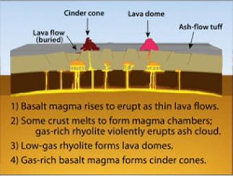
During Basin & Range extension, the plates pull apart, the mantle rises and melts due to lower pressures near the surface. The style of eruption depends on how long the magma sits in the crust and undergoes processes such as crystallization and melting and assimilation of wall rock.
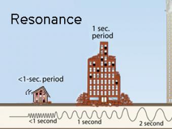
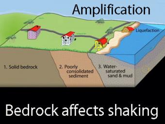
All buildings have a natural period, or resonance, which is the number of seconds it takes for the building to naturally vibrate back and forth. The ground also has a specific resonant frequency. Hard bedrock has higher frequencies softer sediments. If the period of ground motion matches the natural resonance of a building, it will undergo the largest oscillations possible and suffer the greatest damage.
Highly generalized animation reflects the arrivals of P, S, and surface waves to 3 closely spaced buildings. Exaggerated movement of the buildings reflects the relative motion recorded by the seismograms.
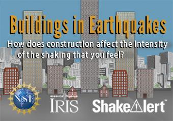
In earthquake-prone regions, buildings can be designed resist being deformed, The way the building is constructed and your position in the building can have an impact on the shaking you feel. Learn more about construction as well as mitigation practices.
We encourage the reuse and dissemination of the material on this site as long as attribution is retained. To this end the material on this site, unless otherwise noted, is offered under Creative Commons Attribution (CC BY 4.0) license
 Loading ...