How can you determine the epicenter of an earthquake?
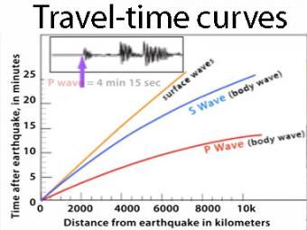
The arrival times of P and S waves are used to determine the distance to an earthquake using standard travel-time curves. P & S waves each shake the ground in different ways as they travel through the Earth. P waves are faster than S waves so by looking at seismograms, scientists can accurately locate the epicenter as well as the hypocenter, or focus of the earthquake at depth. (Recorded during a 2007 teacher workshop on earthquakes and tectonics. Speaker is Dr. Robert Butler, University of Portland Oregon)
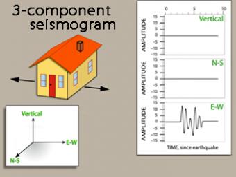
We use exaggerated motion of a building (seismic station) to show how the ground moves during an earthquake, and why it is important to measure seismic waves using 3 components: vertical, N-S, and E-W. Before showing an actual distant earthquake, we break down the three axes of movement to clarify the 3 seismograms.
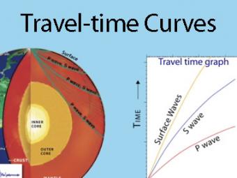
A travel time curve is a graph of the time that it takes for seismic waves to travel from the epicenter of an earthquake to the hundreds of seismograph stations around the world. The arrival times of P, S, and surface waves are shown to be predictable. This animates an IRIS poster linked with the animation.
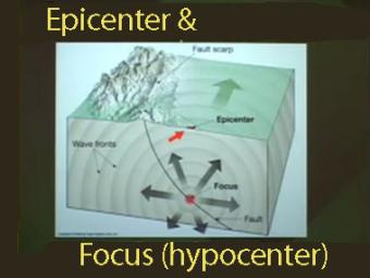
The epicenter is the map location on Earth’s surface, above where earthquake began. An earthquake actually begins inside the earth at the hypocenter. Learn more!

To understand plate tectonic processes and hazards, and to better understand where future earthquakes are likely to occur, it is important to locate earthquakes as they occur. In this activity students use three-component seismic data from recent earthquakes to locate a global earthquake.
We encourage the reuse and dissemination of the material on this site as long as attribution is retained. To this end the material on this site, unless otherwise noted, is offered under Creative Commons Attribution (CC BY 4.0) license