
3min 33s Novice Spanish
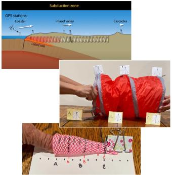
On March 11, 2011, a devastating magnitude-9 earthquake struck off the coast of Tohoku, Japan, where the Pacific Plate dives beneath the Okhotsk Plate. On January 26th, 1700, the West Coast of the United States experienced a similar tsunami-generating megathrust earthquake. An earthquake like this will strike the Cascadia subduction zone again. How can we protect ourselves?
Residents of California, Oregon and Washington now have an earthquake early warning tool—the ShakeAlert© system, operated by the United States Geological Survey.
We encourage the reuse and dissemination of the material on this site as long as attribution is retained. To this end the material on this site, unless otherwise noted, is offered under Creative Commons Attribution (CC BY 4.0) license
